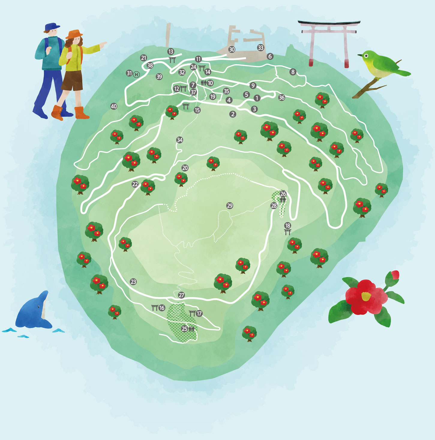



Island Map — All 40 Spots
Shrines, viewpoints, camellia groves, souvenirs — every spot on the island in one map.
On a smartphone, tap 📍 My location to see where you are on the island.
Tap a pin and choose ▶ Directions to open the route in Google Maps.
Tokyo Stroll Island TOSHIMA Introduction (Japanese version only)
See the island as it is today — on Instagram.
Camellia blossoms, ocean views, island life — we share Toshima every day. Take a peek before your trip.
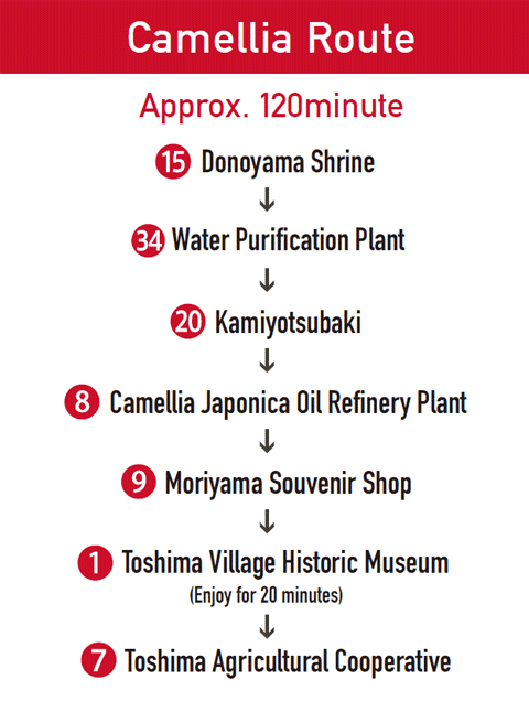
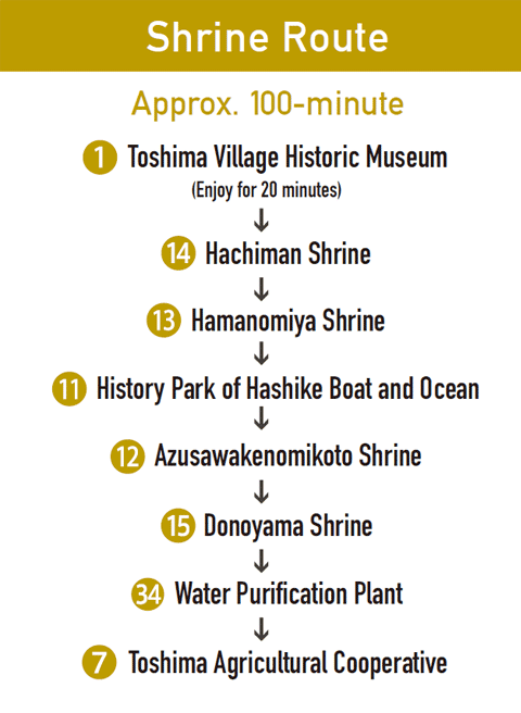
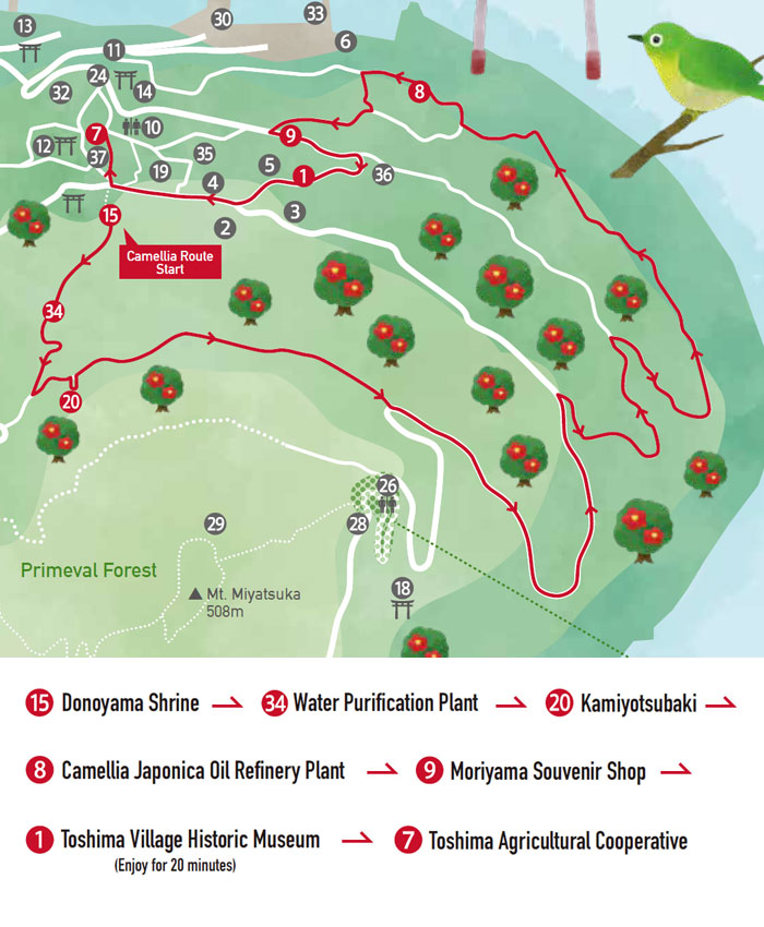
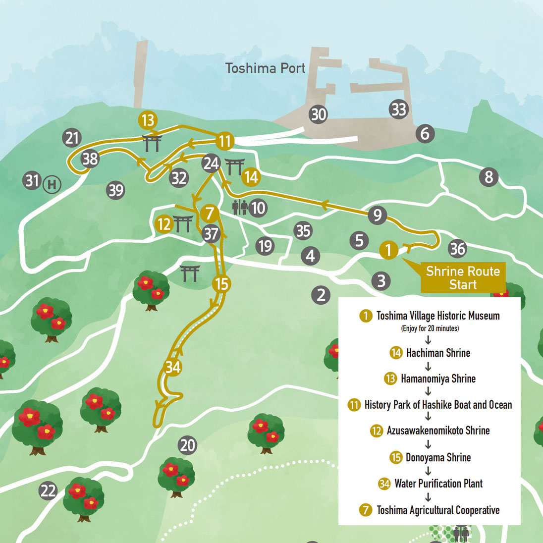
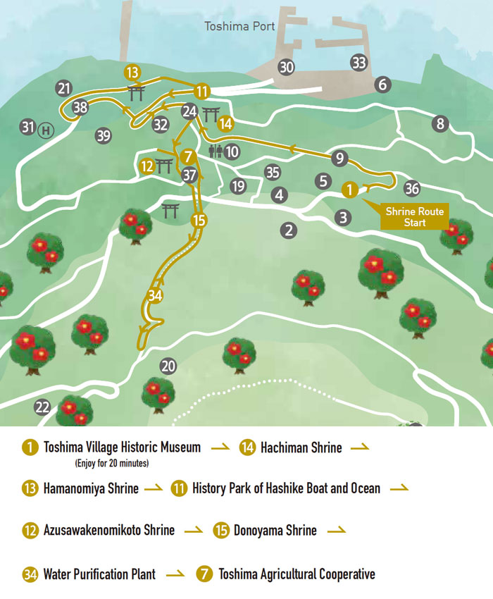
📷 Follow @ja_toshima| Toshima Village Historic Museum | Introduces the history of Toshima from different perspectives. You can also see a diorama model display of Toshima. |
|---|---|
| Labor and Welfare Center | A community lounge for the islanders. You can enjoy bowling here. |
| Community Center | A public space for the island gatherings. It is also used for weddings and funerals. |
| Toshima Elementary School /Junior High School | Routinely used as the practice field for sports-related activities for adults after school hours. |
| Toshima Village Hall | Toshima Village was established during the Taisho era, but people started living on this island in the Jomon period. |
| Toshima Fishery Cooperative | Horned turban shells and Japanese spiny lobsters are the main catches of the island. |
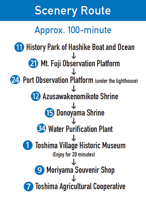
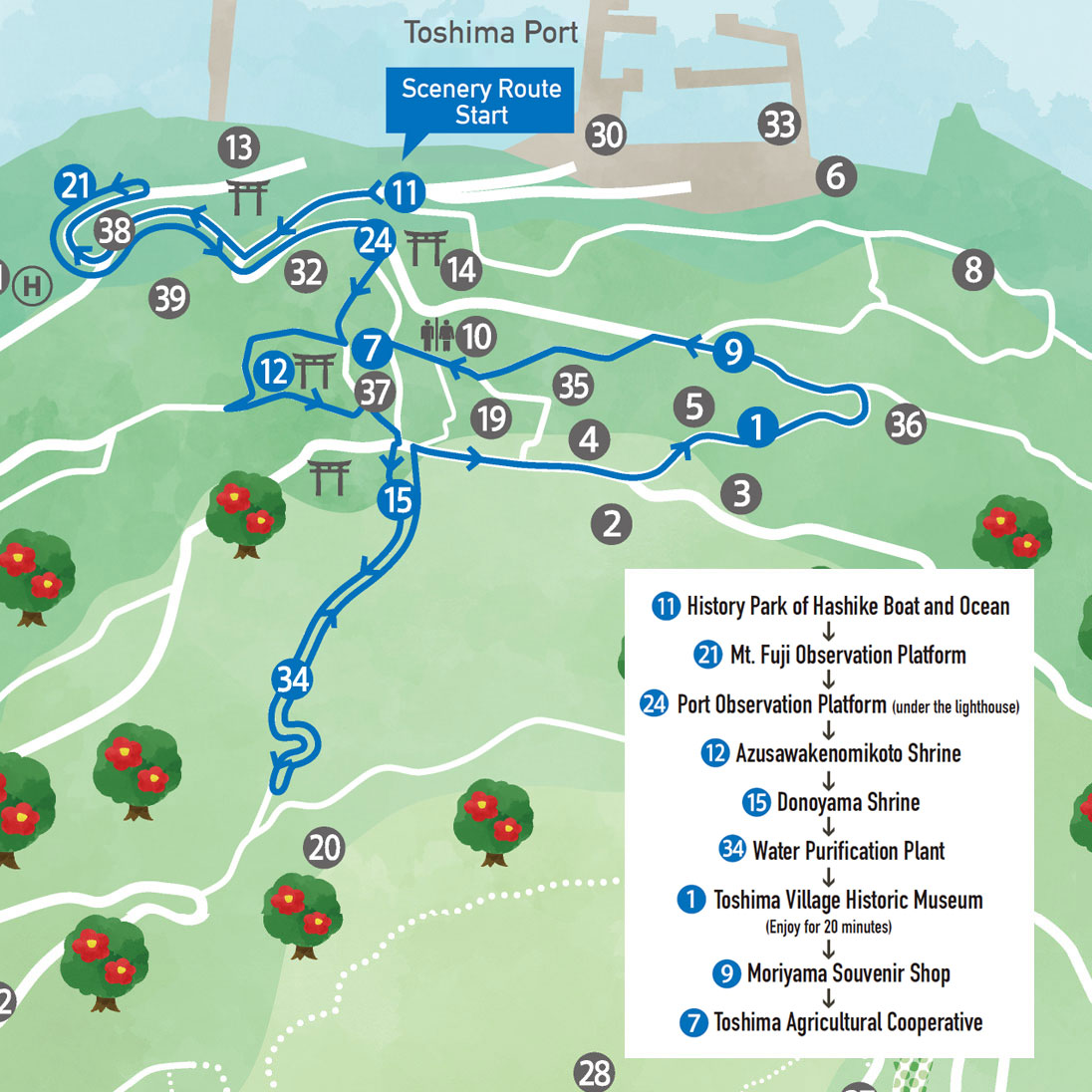
| Toshima Agricultural Cooperative | A shop where most of daily supplies are being sold. Camilla japonica seed oil “Kamiyotsubaki” of Toshima can be found here. |
| Camellia Japonica Oil Refinery Plant | All seeds collected from Toshima camellia japonica trees are carefully selected and extracted here, to make camellia japonica seed oil. |
| Moriyama Souvenir Shop | The only souvenir shop on the island. A good place to stop by for an ice cream or a coffee during the stroll. |
| Nakayoshi Play Park | A playground with swings and a slide for children. A public toilet is also available here. |
| History Park of Hashike Boat and Ocean | Exhibits a boat known as “Hashike” that was used before the port was constructed. You can view Oshima and Mt. Fuji from here. |
| Azusawakenomikoto Shrine | The largest shrine on the island which pays homage to the god Azusawakenomikoto. (A national tangible cultural property) |
| Hamanomiya Shrine | A shrine to pray for the safety of family members leaving the island and sea voyages. |
| Hachiman Shrine | The only shrine among the shrines of the Izu islands that hosted Yabusame archery ritual at one time. |
| Donoyama Shrine | A shrine that pays homage to a god who was enshrined in a private residence in Toshima at an early period during the Meiji era. |
| Azusawakenomikoto Hongu Shrine* | The “goshintai” (object of worship believed to contain the spirit of god)of this shrine is believed to be Mt. Miyatsuka itself. |
| Oyama-koyama Shrine** | Known as the mountain and sea god, Oyamatsumi, is worshipped here. |
| Orinobori Shrine*** | A place that worships the princess of Azusawakenomikoto, Orinobori. Islanders visit this shrine when they finish the mountain trail. |
| Chokyu Temple | The one and only temple of Nichiren sect temple on the island constructed in 1504. |
| Kamiyotsubaki | The earliest known camellia japonica tree on the island. The tree itself has already decayed and only a small root remains. |
| Mt. Fuji Observation Platform | Located in front of the recycling center on the way to the heliport. |
| Hitoyasumi Observation Platform | Offers a panoramic view with many benches. |
| Sunset Observation Platform | A great spot for a photo opportunity on the west side of the island where you can view a remarkable sunset. |
| Port Observation Platform | Located along the road that goes around the island, up the path from History Park of Hashike Boat and Ocean. |
| Minamigayama Picnic Site | A viewpoint with a vista selected as one of New 100 Landscapes of Tokyo. A public toilet area is available here. |
| Usuigo Picnic Site | A viewing area with an observatory platform. A public toilet is available here. This facility’s construction was inspired by a “belief for the ancient deity.” |
| Mt. Miyatsuka South Trail Entrance | Starting point of an easy winding mountain trail. Elementary school children challenge the summit from this entrance every year. |
| Mt. Miyatsuka East Trail Entrance | Starting point of the steepest trail up Mt. Miyatsuka among a few. Located near Orinobori Shrine where people visit to show gratitude for the trail. |
| Lookout at the Summit of Mt. Miyatsuka | The island of Toshima itself is a mountain called Mt. Miyatsuka with its summit being the highest point of the island. |
| Port Waiting Room | Known as “senmachi” by the islanders, this place is an important location for receiving supplies and welcoming travelers from Takeshiba (Tokyo) and Shimoda (Shizuoka). |
| Heliport | Tokyo Ai-land Shuttle connects Toshima and Oshima with one round trip a day. |
| Lighthouse | An unmanned lighthouse located on a hill behind Toshima port. You will see a ladder reaching the road that goes around the island. |
| Toshima Port | All boats, including those used for fishing and for swimming with dolphins, utilize this port. |
| Water Purification Plant | Since there are no rivers or water springs in Toshima, domestic water is supplied by filtering rainwater and purifying seawater. |
| Medical Clinic | The only clinic on the island. |
| Police Substation | The only police substation on the island. |
| Post Office | The only post office on the island. ATM access can only be found here. |
| Recycling Center | Recycles materials such as metal products and cars. |
| Oishi-yama Ruins | Ruins from the early Jomon era to the Kofun period. This ruins is designated as an important historical property of Tokyo. |
| Kekkei Ruins | Pit dwellings from the middle of the Yayoi period, and pottery, ironware, obsidian, from the Jomon period have been discovered here. Also designated as an important historical property of Tokyo. |